Welsh Harp & Fryent Country Park
Our first (half) day out, is a late summer six-mile ramble through Brent and Barnet that starts just six minutes from West Hampstead! On this Sunday afternoon, we watched swans corralling signets in Welsh Harp reservoir, discovered Brent’s oldest building, ate a wild apple, and still couldn’t avoid spotting the Shard.
Factbox ¦ Route map (full size) ¦ Slideshow
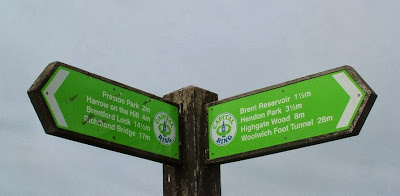
Our path was one section of the Capital Ring – a sort of pedestrian M25 that circles London.
We took the Thameslink north to Hendon (£1.70 with Oyster travelcard) – it really is just six minutes. A brisk cut across Hendon Broadway with its seemingly incongruous fishing tackle shop took us to the glorious leafy surrounds of Cool Oak Lane. There were indeed some cool-looking oaks on this shady walkway, already laden with acorns. There’s a narrow bridge that has its own pedestrian light – when the man goes green the cars have to stop and you can saunter across the bridge. Then head left – despite signs pointing both left and right.
The bridge takes you away from built-up Hendon and into parkland. There’s a lookout platform across the Welsh Harp (aka Brent) Reservoir. This is one of London’s largest lakes and an important conservation area for many bird and mammal species. It’s also home to a sailing centre and there were kids in canoes enjoying the water. Standing in this peaceful spot it was hard to believe we’d been on West End Lane less than half an hour previously. Welsh Harp is named after a pub by the way – I knew you’d ask
Don’t leave it too long before trying this walk – the Welsh Harp area looks like it’s going to be built on in a very controversial large-scale housing development. From a purely environmental point of view, this seems like a terrible shame. To have such open countryside in the heart of north London is fantastic.
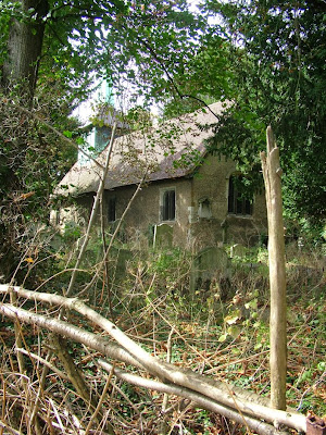
Having walked the length of the reservoir, where there are numerous picnic spots and a few hidden nooks and crannies, we stumbled upon St Andrew’s Old Church (not to be confused with the new St Andrew’s round the corner). The Capital Ring signs don’t take you past the church, instead take the footpath signed “Leading to St Andrew’s Road” and make your way through the spooky graveyard to find it. An ice cream van’s jingle in the distance only added to the horror film vibe.
Amazingly, the church is thought to be the oldest standing building in Brent, dating back to Saxon times. As we approached it seemed a service was ending, but the garb of the small congregation and the priest suggested this wasn’t your run-of-the-mill CofE service. Instead, the church is now home to Romanian Orthodox worshippers. Brent council has a fantastic article on the history of the building, which I wish we’d read before we went.
You soon pick up the Capital Ring path again as it makes it way through the paved front gardens of suburbia to Fryent Country Park. The views open up to the north and it feels as if you have left London behind. The park is more of a heathland with original hedgerows and paths in all directions. The Capital Ring path is well signposted, and where there are multiple paths, look at the directional arrow carefully although there are plenty of ways of getting to the busy main road that bisects the park.
There were sloes, blackberries and even apples in abundance in the park. The latter offshoots presumably of nearby orchards. Aside from a lone jogger, we had the whole area to ourselves, even on a sunny mild Sunday afternoon.
After crossing the road, the park becomes more of a wood, and the path takes the only major climb of the route – a short pull up to Barn Hill.
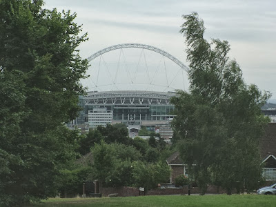
Having barely seen a soul since entering Fryent Park, there were a few families enjoying the pond up here, replete with moorhens. The views of Wembley stadium from the trig point must be hard to beat, and a clearing to the east lets you glimpse the glass and steel structures of the City – the Gherkin and Shard both visible in the haze. For some reason there was a watermelon cut in half and lying on the grass as if picnickers had been forced to leave in a hurry and feared it might weigh them down as they fled.
Coming down from Barn Hill, there’s a temptation to cross the Jubilee Line footbridge, but in fact the path turns left and then disappears right, into a small copse – the signpost is completely overgrown though, but even making a mistake here will lead you back onto the path.
The wilder parts of the walk are behind you – although some might find Preston Road a little wilder than West End Lane. Here’s refreshment in the form of some corner shops (one of which was selling doner kebab flavour crisps!). This is also a bailing out point as you can catch the Met Line from here.
As you reach the picture perfect village school that is Preston Park primary, the path cuts through an appealing small urban park with a playground and cricket pitch (there was a match, but it was tea). Another trip through suburbia the other side and under South Kenton station and you’re almost at Northwick Park.
Here the view is dominated by the enormous hospital, and by military aircraft flying into RAF Northolt. There were a couple more cricket matches here; it was tea here too – at least for the more serious looking one. The Capital Ring takes a very unprepossessing route off through some brambles but we headed on the spur path to Northwick Park station. From here, it’s a 12 minute ride on the Metropolitan Line (£1.50 off-peak) to Finchley Road station and back to the sanctity of NW6.
What to take: The path could be muddy, so not your best shoes. There are shops in Hendon and Preston Road, but that’s about it, so you may want some water/snacks.
Maps: Most of the walk is on Section 10 of the Capital Ring. Here’s the map. (this describes the route in reverse). I would recommend OS Explorer 173 London North (1:25,000), which marks the path as well.
Terrain: well-maintained paths and pavement, undulating, with one steeper section of up/down
Distance: 6.5 miles
Signposting: Very well signposted for the most part, though some signs are small. Map definitely recommended.






Great post!
Tried this yesterday,and despite the miserable weather it is a lovely and rewarding experience. We decided to cut it a bit shorter by walking down Barn Hill to Wembley Park station as we were getting a bit tired! lightweights!